A Walk through Time: A guided walk round the Town
Starting from the main Car Park (close to the church) walk past the Jubilee Hall (built to commemorate the Silver Jubilee of King George V in 1936) and then turn left into New Street.
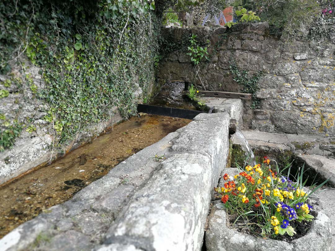
Many of the cottages in New Street are 16th & 17th century and Grade 2 listed. Continue a short distance to the granite lined stream on your left running between low granite walls (1). Take care here as the pavement is very narrow. This is known as Turnlake which may be a corruption of Town Lake, the first Town water supply. It may also refer to the diversion of water at this point for a leat travelling over O’re Hill which you will see as you continue on your walk. Looking across the road from this point, you will see the entrance to Stannary Place which was a garage until 1994. Behind it was once a livestock and annual pony sales market.
Rock Cottage on the right-hand corner was a bakery from 1900 until the 1950s.
Cross over and continue past the modern houses for a short distance, crossing the entrance to The Acre. From here, look across the road and you will see no. 20 which was once the police house. Note the canopy over the door and noticeboard hooks on the walls. No.24 was the School Master’s house, probably late 19th early 20th century.
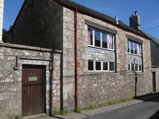
The school (2) next door was opened in 1861 on the site of a Care House for the poor of the Parish. The room was 46ft by 16ft holding approximately 150 children. The school was enlarged as numbers increased to 180. The Primary School moved to the present site on Lower St. in 1971 when the Secondary School pupils moved to Okehampton.
Walk down the track opposite the Old School and look over the gate to O’re Hill which is one of the Open Fields for those holding common grazing rights for cattle, sheep and poultry and is unlocked between 6th August and 6th November. You will see the leat which has flowed underground from Turnlake and along the right-hand side of the track, now curving around the hill on its way to the woollen mill in Mill Street, now Moorlands (see 15 below). Returning to the road, the three cottages on the corner of the track on your right, numbers 25, 27 and 29 were once a large smithy.
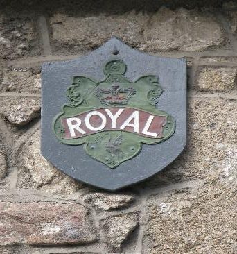
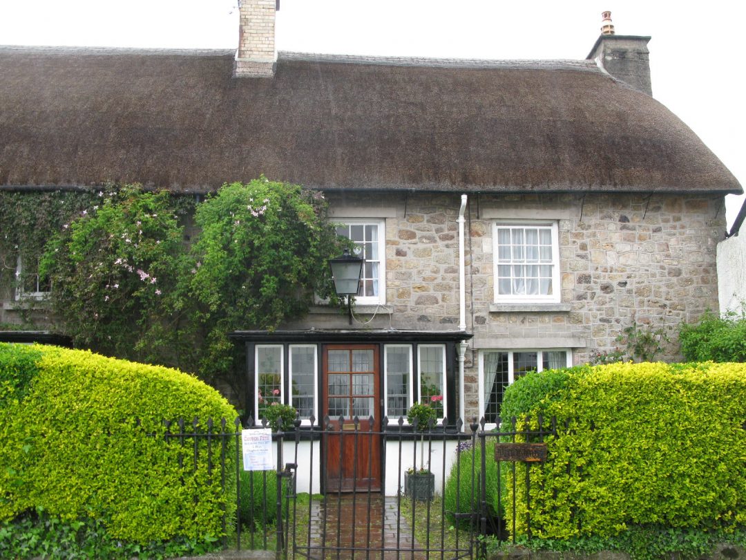
Continuing along the street, note the insurance plaque on no. 41, which was once the White Eagle Inn (3). Prior to 1900, these plaques indicated to firemen that the building was insured and that they would be paid for saving the building.
Continue past the point where the houses end and New St. becomes Meldon Rd. About 200 metres along on your right is a walled open area which was once the Town Pound where stray animals were kept until their owners paid for their return. Next to the Pound is the former slaughterhouse dated 1893.
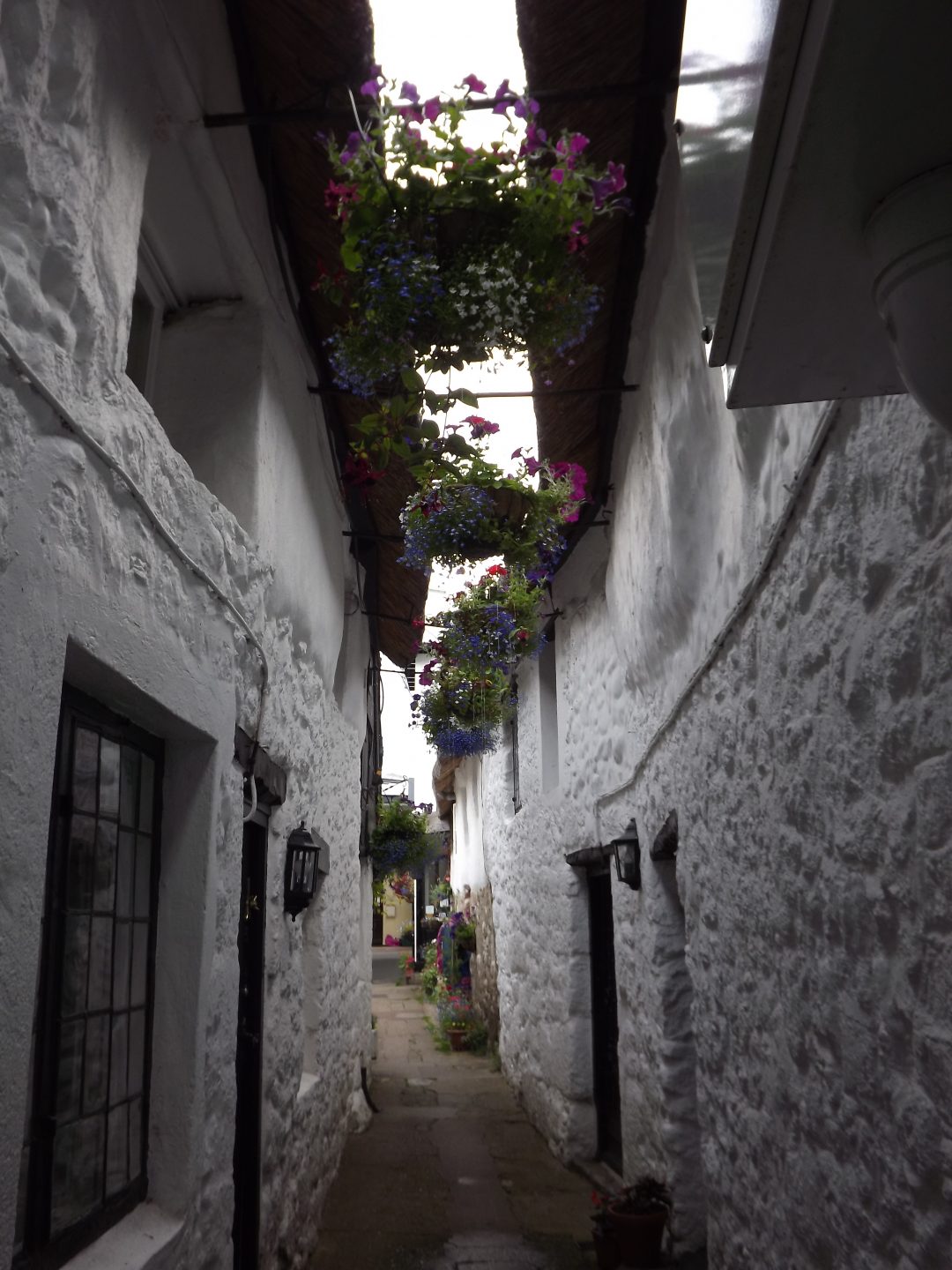
Retrace your steps and turn left at Stannary Place. On the righthand side, behind Rock Cottage, you will see a cobbled entrance to the back of the Globe Inn. This leads into the coaching yard and the converted sheds where horses would be stabled. To the left of this driveway is a tall rendered building which was once the Assembly Rooms and it was here that people gathered for concerts and money raising events, and where Chagford men were called to arms at the beginning of the Great War. In the 1920s it became Chagford’s main entertainment building, the Rex Cinema, until it closed in the1960s. Continue forward, then turn right into Store St. known as the Drang (4). You will see small doors on the right as you proceed down the Drang which were the entrances to pigsties and stables.
You will see the street ahead of you and as you pass towards the end of the Drang, note the bars on the side window of Whiddons, which was once a post office.
Emerge onto the High Street
On your right is Church Stile Cottage – as the name suggests there was once a stile in the Churchyard wall opposite. Beyond this is the Globe Inn, an early 19th century coaching inn.
5. Endecott House
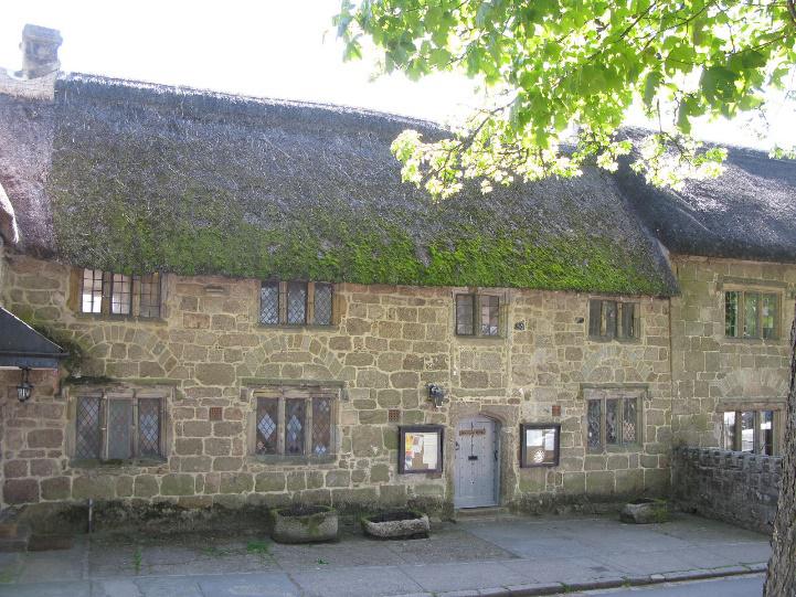
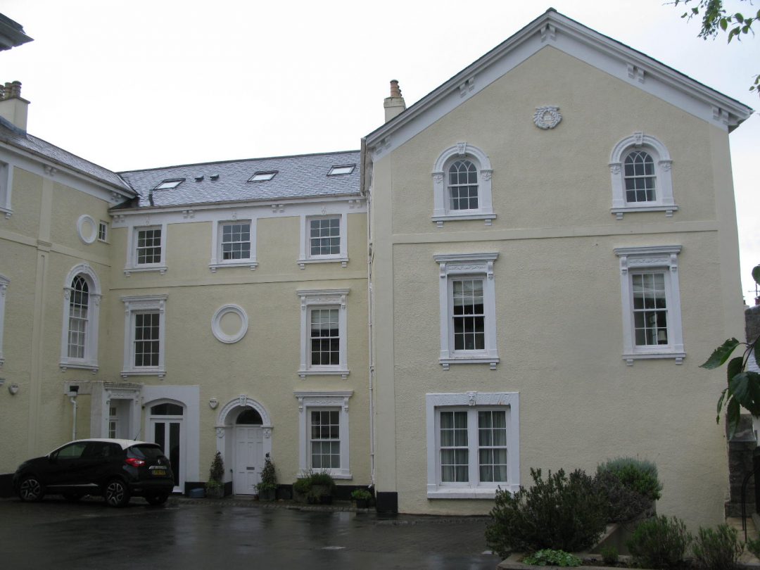
On your left, beyond Whiddons, is Endecott House (5) which is 15th century and Grade 2* listed. It was administered by the Churchwardens and used by Church Guilds as well as for brewing Church Ales. Later it became a Care House where the poor of the Parish were housed. In the late 18th century a schoolroom was created upstairs while the poor were cared for on the ground floor. A stone staircase on the outside led from the ground floor to the upper floor and although no longer there, if you look carefully, you can see the stone work indicating where the upper floor was. In 1853 an infants’ school opened on the ground floor while older children were taught on the first floor. After the move to the school in New St, Endecott House continued as an infants’ school until 1936. Previously known as St. Katherine’s House after the Patron Saint of Tinners, it was named Endecott House following refurbishment in the 1980s in honour of John Endecott, first governor of Massachusetts, who emigrated from Chagford in 1628. It is administered by a group of trustees and used for a variety of events. A charity coffee morning is held here every Saturday throughout the year, giving the visitor a chance to view the interior of this historic building.

6. The Three Crowns
The Three Crowns (6) is early Tudor and Grade 2* listed. It was owned by Sir John Whiddon who died in 1575 – his tomb is in the Church. His daughter, Mary, left her home here to cross to the Church on her wedding day. She was shot by a jealous suitor as she left the Church after the ceremony. It is believed that this inspired R.D. Blackmore to write his story Lorna Doone. In 1643 a skirmish took place between Royalists and Parliamentarians. Sidney Godolphin, 33, a poet and MP for Helston in Cornwall was shot and carried to the porch here. Thus, said Lord Clarendon “leaving the misfortune of his death upon a place which could never otherwise have had a mention in the World”. In the 19th century it became the Black Swan and later the Three Crowns.
Now cross the road to the iron gate in the Churchyard wall.
To the right of the gate you will notice that the wall has been reconstructed where the granite slab stile on which coffins were rested on the way to funerals was removed. It is for this stile that Church Stile cottage opposite was named. A little further along the wall to the left you will see an arched niche which once housed an electricity transformer – a reminder of Chagford’s original generating system situated on the site of the earlier woollen mill at Factory Cross at the bottom of Mill St.
Go through the gate to the Churchyard and take the path on the right towards the church tower. On the left along this path, just opposite a conifer tree, you will see a distinctive gravestone with an inscription on both sides. This marks the grave of one of the 19th century “Men of the Moor”, James Perrott. He was a Dartmoor guide who led walks for tourists and visitors across the Moor, and who instigated the now popular pastime of “letter boxing.” The first was at Cranmere Pool. He also organised fishing trips and sold fishing tackle from his shop in the Square. He kept ponies and carriages which he hired out. On his fishing expeditions, he sometimes led Charles Kingsley, R.D. Blackmore, and Charles Dickens, (all of whom stayed at the Three Crowns) and other famous men of the Victorian era. You may wish now to enter the church by the modern glass door on the northern side.
Inside the Grade 1 listed Church you will find all the information you need for a self-guided tour. (or visit the St Michael’s pages on the website here).

7. St Michael the Archangel
On leaving the Church, walk round to your left beneath the tower towards the south porch. On passing the west door, look up to the 13th century arched window and the statue of St Michael the Archangel (7) in the niche below. This sculpture was carved and given to the church by John Skeaping R.A. a previous resident of Chagford, in memory of his friend and deceased incumbent, The Rev. C.H.S. Buckmaster. John Skeaping will be best remembered perhaps, for his life size sculpture of the famous horse Hyperion, which stands in the entrance hall of the National Gallery in London, and for his marriage to another famous sculptor, Barbara Hepworth.
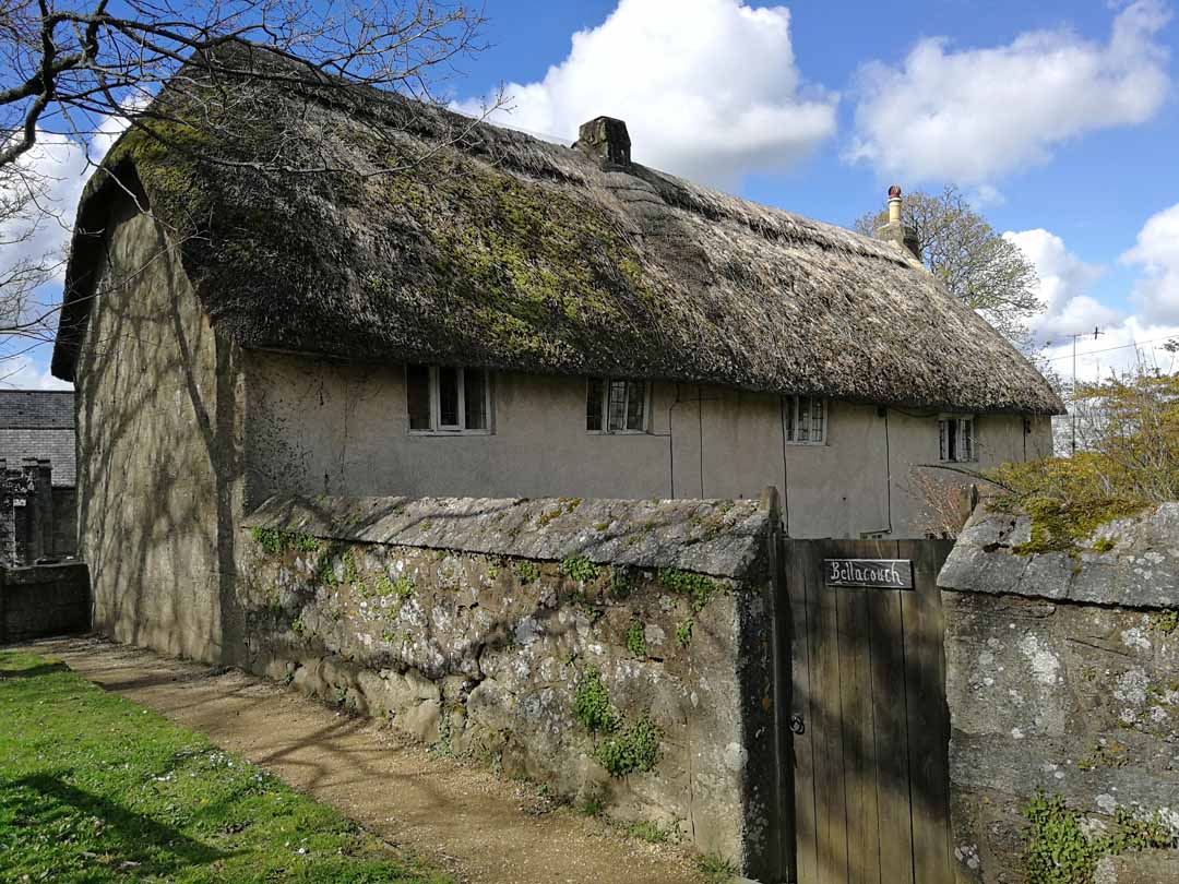
8. Bellacouch
On reaching the south porch, turn right up the path leading to wooden gates. Beyond the gates is “Cross Tree” where the oak tree signifies that this was an ancient gathering place for groups attending christenings, weddings and funerals before walking down the path into the church through the south door. Beyond this, across the road, you will see two stone pillars which mark the entrance to Chagford House, a Georgian building and the home of the Hayter-Hames family, generous benefactors to Chagford, and major landowners here through time. Please note that this is a private dwelling. Turn around and take the church path immediately on your right which leads slightly downhill to the graveyard. The long house on your right, Bellacouch (8), is one of the oldest in Chagford and possibly an early home for the priest.
As you pass Bellacouch, you may hear the water of the stream which has flowed underground from Turnlake. If you look up to the church roof, you will see a small headless stone figure on the ridge marking the division of the present chancel from the nave. This is a lamb, the Agnus Dei, which indicates Chagford’s importance as a wool town. Continue walking and you will see halfway down this part of the churchyard to your right the granite memorial cross and its plinth which once stood in the town Square. It commemorates those of Chagford who fought in the world wars for their country.
Now turn to your left and walk down the yew path. A very short way down on the right, you will see the grave of W.S. Morrish (1844-1917) noted for his fine watercolours of Dartmoor scenes and a friend of the famous Dartmoor painter F. J. Widgery.
At the end of the path you will come to the lychgate. Beyond this and down the steps, one of the cottages on the right was where Morrish lived. You now come to the bottom end of the Lower Square.
Just a short distance to the left, beyond the listed telephone box, is where Chagford’s Post Office carried out business from 1824. Mail was brought by train to Moretonhampstead station, and then by horse and cart to Chagford Post Office. Run continuously by five generations of the Thorn family, the Post Office finally closed in 2015.
Chagford Square is actually much bigger than you think and is divided into two sections. The top area is known as the Square and the lower part as the Lower Square. In the centre of the two areas is a collection of houses and shops, with hardly any space between each, known locally as the Island. Proceed down the road on the southern side to the Lower Square. On the way, we will pass the only garden on the island, and one of only two gardens that actually edge onto the Square. At the bottom of the Island is a stone trough with a tap emerging from the granite column behind it which houses a water tank. It was given to the town by a Col. Germon for animals to drink from. This is known as the Fountain, and has been in the protection of the Parish Council for use by all since it was provided in 1889. At the bottom of the Lower Square on the right is Orchard Terrace with Orchard Cottage at the top, one of the original farms in the town.
You are now walking downhill on Southcombe Street
Cranley Gardens on the left provides sheltered housing, It is built on the site of an abattoir which later became allotments. Opposite is the Gospel Hall formerly the Ebenezer Hall founded by the Plymouth Brethren and opening as a Baptist Chapel in 1827.
On the left-hand side is Rock House, now Rendells Estate Offices. In 1904 this was the Great Western Parcel Office for the area, and steam buses ran from here to Exeter. Southcombe House was built in 1871 and was originally a farm. Its close proximity to Rock House (now Rendells) is due to a feud in which revenge was wrought by the owner of the Rock House land by building his house as close to the front door of Southcombe House as possible, thus destroying the view from there towards the town.
Lower Street starts immediately after this. The houses at the top of the street date back to the 16th century and perhaps even earlier, some hidden behind 19th century facades.
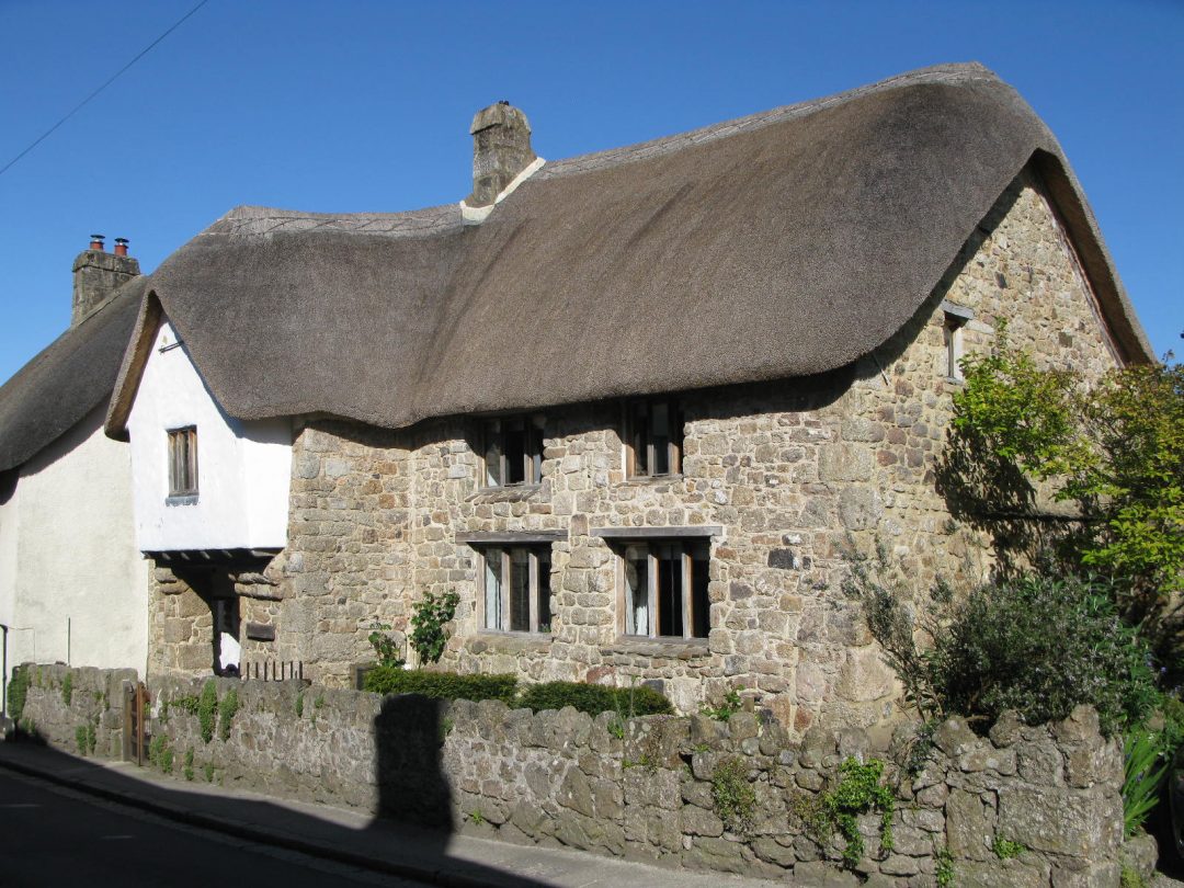
9. Bishop’s House
Bishop’s House (9) is a late medieval cross passage house and is Grade 2* listed. It was so called as it is said to have been associated with Bishop Branscombe who dedicated the Church in 1261. Note the oriel window on the upper floor over the porch.
Return up the street towards the Square
On the right-hand side, between the Beehive Café and the house below, you will find an entrance to the buildings which were the site of Aggett’s Church Bell Hangers. It was founded in the 18th century by James Aggett whose ancestors began bell hanging in the 13th century. Aggett invented and patented the chiming apparatus which attach to bells and enable recognisable “tunes” and hymns to be played from a bell tower. Walking up the street on the north side of the Island, (known as North Street in fact) you will see, on the right-hand side just after the driveway to the cottages behind those bordering the road, a tall niche in the wall. This once housed the first, and for a while the only, petrol pump in Chagford. The shops to the left formed a garage until the 1950s, when the premises were bought by R.E. Short and converted into shops, one of which sold electrical goods and the newly popular television sets. One of the shops was bought by an electrician, C.J. Knott, who invented the Knotts transmitter on these premises. His invention went on to assist the first manned spacecraft back to earth.
10. Lydstone
The final building on North Street, also verging on the Square, is Lydstone, which is attached to Kings Arms Cottage. Together these two homes originally formed a coaching house with a courtyard behind, known as the Kings Arms Hotel. If you look carefully through the rails of the gate you can see the original cobbles over which pony and traps would have travelled taking visitors onto Dartmoor. The door which exists today would have been an open archway, and the trap would have been pulled through what is now the central hall of the house, from the courtyard at the rear.
You will now find yourself in the Square
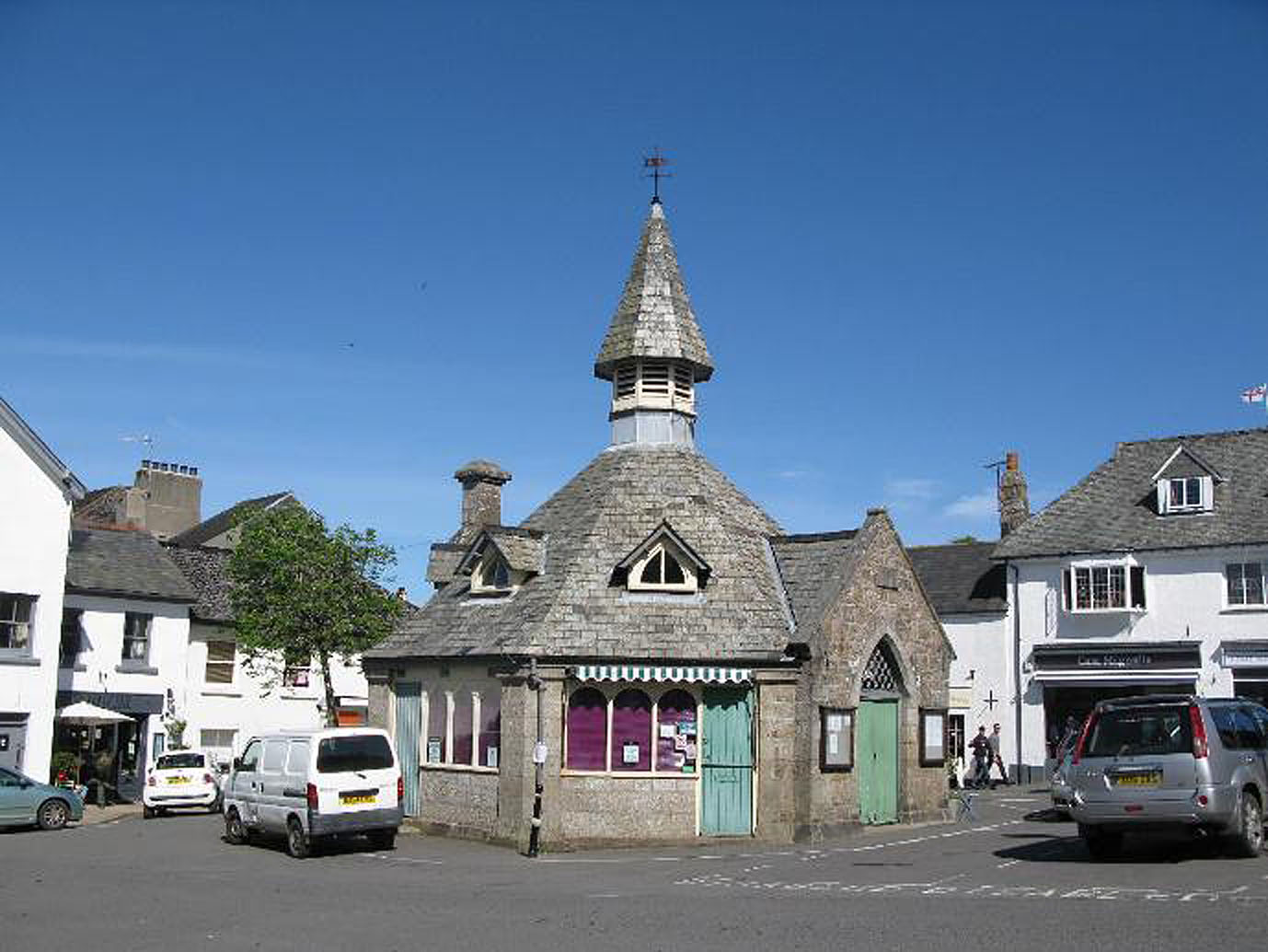
11. Market House
The octagonal Market House (11) in the centre of the Square was built in 1862 to replace the Shambles, a thatched building which fell into disrepair. An early Charter for Fairs and Market in the Town was granted by Henry VIII. The toll board, now in Endecott House, shows that it cost three pence to enter a cow or calf, two pence to sell from a cheese cart and a penny to sell nuts. It was to here that the smelted tin was brought twice a year to be assayed, stamped, taxed and sold.
Look across the High Street to the Ring O’ Bells. It is thought that the upper floor was used for the “Crowner’s Court”. The Coroner had to be summoned from Exeter.
The Spar shop to the right was Webber & Sons, started in 1870 by William Thorn. It was purchased by Gideon Webber in 1898 who continued the trade of saddler and harness maker. Later it extended to include ironmongery, hardware and cycles. By 1920 petrol was sold in two-gallon cans, wireless sets were made and phonograph records cut. By 1942 Webbers incorporated the next door premises of George Collins (butchers) and James Perrott (referred to in the Churchyard). This family business continued for five generations until retirement caused it to cease trading in March 2017.
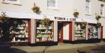
The Spar shop to the right was Webber & Sons, started in 1870 by William Thorn (12). It was purchased by Gideon Webber in 1898 who continued the trade of saddler and harness maker. Later it extended to include ironmongery, hardware and cycles. By 1920 petrol was sold in two-gallon cans, wireless sets were made and phonograph records cut. By 1942 Webbers incorporated the next door premises of George Collins (butchers) and James Perrott (referred to in the Churchyard). This family business ontinued for five generations until retirement caused it to cease trading in March 2017.

13. Bowden & Son
Bowden & Son (13) was the Vulcan Ironworks making agricultural implements in 1862, later becoming an ironmonger’s. In 1922 they constructed the first radio valve set in Devon and queues formed to hear it. A hand operated fire engine was kept here and horses had to be caught and harnessed before it could be used. Bowden’s ran a bookmaker’s from 1960-1970 in a cottage to the rear of the shop. They expanded into Bolt’s the Grocers, the premises next door, in 1971. Walk through the shop, go upstairs to the gardening section and you will come to a small but fascinating museum.
From here, cross over and continue West down Mill St on the right-hand pavement
The thatched building on the corner is the former Lloyd’s Bank and is thought to have been the only thatched Lloyd’s bank in England, the deeds going back to 1735. It was a blacksmith’s until 1842, was converted into two cottages and a shop before Lloyd’s bought it in 1918. The bank closed in May 2017.
The Chagford Inn dates from 1844. Previously named Bakers’ Arms and then the Buller’s Arms, named for General Buller after the Boer War. Note Ladysmith House next door.
Helpful Holidays, one of Chagford’s largest employers, was a Methodist Chapel and former school room. It closed as a religious building in 1998.
Claremont was the home of the local doctor and a room here was devoted to his surgery prior to the purpose-built surgery adjacent to the car park.

14. Lawn House
The thatched building opposite is Lawn House (14). The original builder and occupier is uncertain. It may have been built by the mill owner John Berry, who was held in great esteem, “being second only in the County in importance to the Earl of Devon”. The Lawn is across the road, and is now the town Bowling Green.
15. Moorlands
Opposite the Bowling Green, the large cream building, Moorlands (15), was one of the woollen factory buildings mainly used for finishing cloth. Much trade was done with the East India Company and the last military order was for horse blankets in the Crimea. When the factory closed in the late 19th century the building became a hotel and in the early 2000s it was converted to flats.
Your tour of Chagford ends here and you may wish to retrace your steps and explore further. Alternatively, if time permits, you could return to the town from this point by one of two short circular routes, taking up to one hour each. Please be aware that these walks can be quite wet underfoot at certain times of the year.
1. Riverside Walk
Follow the road signposted to Gidleigh. Turn right at the cross roads to the stone bridge from which Chagford gets its name. Look back at the ruins of the woollen factory dating from the early 19th century. Cross the bridge, go through the gate on your right and follow the path to the next bridge – Rushford Bridge. About 200 metres along to your left is Chagford Open Air Swimming Pool, situated beside Rushford Mill Farm. To return to Chagford, retrace your steps back to Rushford Bridge and carry on up the road, turning right at the junction.
2. Padley Common
Follow the road to the left signposted Fernworthy Reservoir and continue past the houses to the entrance to the Memorial Playing Fields on your left. Follow the path through two kissing gates and continue over Padley Common until you reach the road where you turn left to return to the Square.
Updated September 2024.